
Authors: Jolanta Kryspin-Watson, Shoko Takemoto, Dixi Mengote-Quah, Jian Vun
Floods are among the most frequent hazards globally, with nearly a fifth of the world’s population, many of whom live in cities, and are at direct substantial risks of 1-in-100-year flood events. While there is no shortage of innovative ideas and approaches when it comes to building resilience to floods, it will be key to translate these ideas into actions.
Working with our partners in Japan, Indonesia and Singapore, we’ve tackled this challenge by integrating a pair of interactive and tangible tools into resilience planning which can help planners make sense of innovative ideas, apply these to their own flood risk challenges, and inspire action for the future. Research shows that the use of tangible user interfaces in planning improves collaboration and communication to address complex challenges holistically.
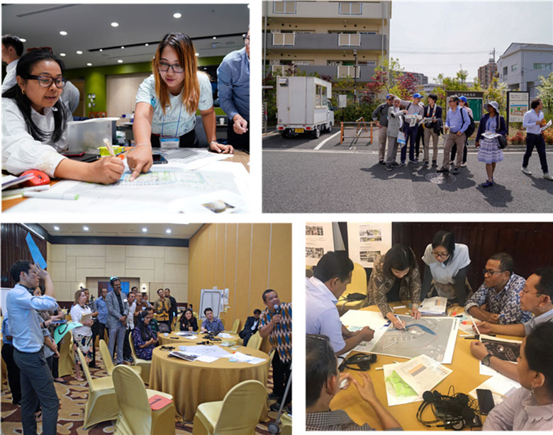
With financial and technical support from the Japan-World Bank Program for Mainstreaming Disaster Risk Management (DRM) in Developing Countries and the Tokyo DRM Hub, under our “mini studio” design exercise, participants in Japan, Indonesia and other countries, explored urban areas to get firsthand awareness and understanding of the flood resilience challenges, and subsequently worked collaboratively to design proposals for addressing them.
In “mini studios,” participants drew on their wealth of experience and expertise to develop innovative proposals with combined simplified stormwater runoff calculations with the physical design of green and gray stormwater management solutions. These innovative nature-based solutions are now being adopted as part of urban flood resilience investment projects supported by the World Bank in countries and cities that have participated in the “mini studio,” such as Indonesia.
The Tokyo, Japan “mini studio” was part of a multi-country technical deep dive on integrated urban flood risk management with 60 representatives from nine countries. In Bogor, Indonesia, the mini studio was held during a national-level workshop on urban flood resilience with representatives from five Indonesian cities.
Over the past year, COVID-19 has profoundly altered our capacities for physical interaction. The good news is that while still experimental, digital platforms have presented new opportunities that transcend geographical distance and enable tangible learning.
The World Bank—in partnership with Singapore’s National Water Agency (PUB) and the National University of Singapore (NUS) School of Design and Environment—developed a virtual site visit with interactive 360° photos of Singapore’s nature-based urban flood resilience infrastructure as part of a technical session for the 2020 Understanding Risk conference (UR2020). The virtual site visit enabled participants to explore the benefits of integrated nature-based solutions (NBS) for stormwater infrastructure as part of the Singapore’s Active, Beautiful, Clean Waters (ABC Waters) Program. PUB shared virtually four projects, located along a river in Singapore’s central catchment, that demonstrate approaches to (1) mitigate the impact of heavy storms, such as multi-use floodplains; (2) detain and treat stormwater runoff; and (3) achieve social and environmental co-benefits.
Virtual Site Visit of Green Infrastructure and Nature-Based Solutions for Urban Flood Resilience in Singapore’s Kallang River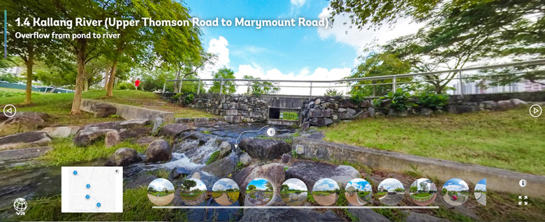
While this is a primarily visual experience, it offers visitors the freedom to explore and interact virtually with the physical space. The virtual site visit, which can be downloaded and used offline, allows a wider audience to explore the benefits of integrated nature-based solutions (NBS) in the design of stormwater infrastructure. The virtual site visit provides a rich, curated and inclusive learning experience by leveraging digital tools, like 360° photos, videos, maps, diagrams, and interactive pop-ups.
The World Bank continues to expand interactive and tangible tools to help turn innovative ideas into urban flood resilience action. An E-Learning course titled “Integrated Urban Flood Risk Management (IUFRM): Lessons from Japan” was recently launched on the World Bank Open Learning Campus (OLC). There is the potential to develop further tools by drawing upon new technologies and platforms that connect digital technologies with analogue sensory experiences such as AR, VR, UAVs, 3D printing, etc[1]. Tangible tools are important because they allow stakeholders to consider how urban risks and urban infrastructures are experienced. Given the global nature of resilience design and planning today, digital tools that support tangible learning are particularly relevant. They can also support community participation by allowing for residents to virtually ‘walk through’ potential resilient transformations before the decisions on specific solutions are made.
1 Related efforts may include:
Virtual reality film highlights climate change impacts in Fiji
Resources:
The Community- and Nature-Based Solutions for Integrated Urban Flood Risk Management Mini Studios for Water-Sensitive Urban Design: A Handbook for Organizers and Facilitators: is a step-by-step guide for technical and nontechnical audiences including government officials, city planners and practitioners, academics, community groups, and others.
Related:
Integrating Green Solutions for Urban Flood Resilience
Integrated urban flood risk management: Learning from the Japanese experience
Urban flood resilience in Indonesia: New approaches through an urban design lens
