
OVERALL PROJECT SCOPE AND IMPLEMENTATION
How will JUFMP/JEDI help mitigate floods in Jakarta?
Over the years, sedimentation and solid waste accumulation have significantly reduced the water carrying and retention capacities of Jakarta’s existing flood management infrastructure. Studies have shown that the restoration of these floodways, canals and water retention ponds is the most beneficial short term step to help alleviate the impact of flooding in Jakarta. Comprehensive hydraulic modeling of recent major flood incidences has shown that the extent and impact of these floods would have been significantly less had the city’s flood infrastructure been operating at their full design capacities. Fifteen priority sections of floodways, canals and water retention ponds in Jakarta have been identified to be restored with the support of this project.
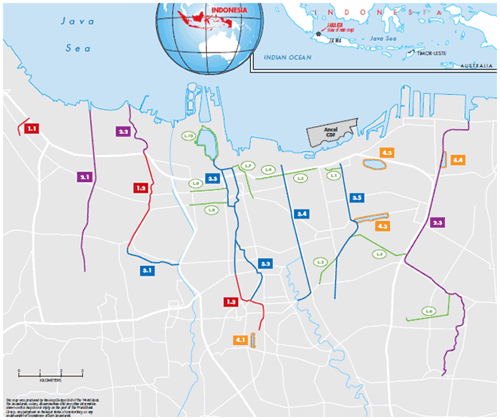
Which floodways and basins will be dredged?
Sections of the following floodways, channels and retention ponds will be rehabilitated with the support of the JUFMP/JEDI project: Ciliwung-Gunung Sahari Floodway, Waduk Melati, Cengkareng Floodway, Lower Sunter Floodway, Cideng Thamrin Drain, Sentiong Sunter Drain, Waduk (Pond) Sunter Utara, Waduk Sunter Selatan, Waduk Sunter Timur III, Tanjungan Drain, Lower Angke Drain, Upper Sunter Floodway, West Banjir (Flood) Canal, Grogol Sekretaris Drain, Pakin – Kali Besar – Jelakeng Drain, Krukut Cideng Drain and Krukut Lama Drain. The 11 floodways / canals are estimated to have a total length of 67.5 km, while the four retention basins estimated to cover a total area of 65.1 hectares. About 42.2 km of embankments/walls are expected to be rehabilitated or constructed within these floodways, canals and retention basins.
What is the status of the project implementation?
The first phase of dredging works to restore the capacity of existing drainage canals commenced in November 2013, with the commencement of four physical works contracts at various project locations (out of a total of eight works contracts supported by the project). One other works contracts are at the final bid evaluation stage. The remaining three works contracts are expected to be carried out in 2015.
Who is implementing the project?
The flood management infrastructure in Jakarta falls under the responsibility of three different agencies: (i) the Directorate General for Water Resources (DGWR) of the Ministry of Public Works (MoPW), (ii) the Directorate General for Human Settlements (DGCK) of the MoPW, and (iii) the Provincial Government of DKI Jakarta (DKI Jakarta). Each will be responsible for competitively procuring contractors to carry out the dredging and rehabilitation works in the locations under their respective responsibilities. The DGWR has established a Central Project Management Unit (CPMU) to oversee and coordinate the overall implementation of the project. This includes managing a common construction supervision consultant who will be responsible to help supervise the contractors’ work.
Will these works be sustainable?
The dredging and restoration of the canals and retention ponds is expected to reduce the extent and duration of flooding within the areas cover by these infrastructures. However, routine operations and maintenance (O&M) of the systems are required in order to ensure that the systems maintain their full operational capacities. DKI Jakarta and the Ministry of Public Works have recognized the need for periodic maintenance. Drainage O&M divisions have been formed and funding is being increased. Insufficient data and ability to analyze the available data also hampers the development of clear programs of action for O&M (as well as the other abilities such as flood contingency planning). With the support of a Government of Netherland’s grant, the project has helped established a Flood Management Information System (FMIS). The FMIS will help strengthen Jakarta’s flood monitoring and assessment capacity, as well as it O&M planning capacity.
THE ROLE OF THE WORLD BANK AND OTHER DEVELOPMENT PARTNERS
What is the rationale for the World Bank in helping mitigate floods in Jakarta?
As a development partner of Indonesia, the World Bank is keen to support the economic development of the country. As the country’s main commercial hub, Jakarta contributes about 25% of Indonesia’s non-oil Gross Domestic Product (GDP). The efficient functioning of the city is critical to Indonesia’s economic development. At the same time, Jakarta is a population hub, with nearly 10 million in the city and 30 million in the metropolitan area. As such, supporting efforts to improve and increase the access to basic public services and adequate flood mitigation to Jakarta is a priority for the World Bank. The project will also help strengthen the capacity of key Indonesian institutions and agencies, and support decentralization by demonstrating a system of transfer of funding from central to local governments for economically beneficial projects.
Who are the other major development partners supporting flood mitigation efforts in Jakarta?
The Netherlands is a key partner and has been supporting flood mitigation efforts in Jakarta for a significant period of time. Netherlands-financed activities have piloted dredging efforts, developed hydraulic modeling and flood hazard mapping, and helped established the Flood Management Information System (FMIS) in Jakarta. The Netherlands is currently supporting efforts to develop a master plan for the long term coastal development and sea defense for Jakarta. The Japan International Cooperation Agency (JICA) has previous financed various flood related studies and infrastructure in Jakarta. JICA is currently developing a wastewater management project in Jakarta. Australia is also a key partner supporting floods related studies, as well as disaster contingency plans and preparedness (through the Australia-Indonesia Facility for Disaster Reduction, AIFDR).
What are the longer term plans for floods management in Jakarta? How is the World Bank helping in this regard?
DKI Jakarta is currently undertaking an assessment of the flood management zones in Jakarta to update the latest requirements. A World Bank – European Space Agency (ESA) collaboration carried out carried out a detailed and accurate land subsidence analysis in 2011 which is contributing to this assessment. The World Bank has followed up with recent technical assistance to DKI Jakarta, by providing hydraulic modeling, design and optimization of reconfiguration of schemes in various flood management zones. In the meantime, DKI Jakarta and central government (with support from the Netherlands) are developing longer term plans to augment the existing sea defense walls and create a comprehensive coastal defense system. The World Bank is coordinating with stakeholders to synchronize efforts.
ENVIRONMENT AND SOCIAL SAFEGUARDS
Is the dredge material hazardous?
The quality of the sediment materials in the project sites have been tested during project preparation and no hazardous waste material were found. Nevertheless, all sections to be dredged will be pre-tested again before project contractors will be allowed to carry out dredging. In the unlikely event of hazardous material being found, the relevant section will be marked and closed. The material will be separately removed and taken to a pre-identified hazardous waste disposal facility, in accordance with national regulations.
What happens to the sediment after it has been dredged out?
Project dredging works are expected to produce about 3.4 million cubic meters of dredge sediment. Non-hazardous sediment will be utilized for an ongoing reclamation at a monitored Confined Disposal Facility (CDF) located in the Ancol area the North Jakarta coast. Solid waste will be disposed of at the Bantar Gebang landfill in Bekasi, West Java. Hazardous sediment material (if found) will be disposed of at the PPLi Hazardous Waste Facility in Bogor, West Java.
Is a Confined Disposal Facility (CDF) suitable for the disposal of dredge material? Is the use of dredge material for reclamation purposes safe?
The use of both land-based and sea-based CDFs to store and manage material from dredging activities in canals, navigations waterways, port facilities, etc., is fairly common throughout the world. CDFs have been constructed for later multi-purpose use such as public recreational area and for industrial structures. There are also CDFs that have been constructed to store and contain material which are potentially hazardous. The CDF at Ancol is designed specifically with later multi-purpose development in mind, and only non-hazardous sediment material will be disposed of at this facility.
What are the impacts on adjacent communities from project construction and implementation activities? How would these be mitigated?
All efforts will be made to minimize impacts to adjacent communities during construction. However, some disruptions and inconveniences will be unavoidable. These may include noise, dust, construction vibrations and traffic congestions (some night time traffic will be unavoidable due to local regulations permitting the transport of certain material only at night). Project contractors are required to prepare and implement an approved Traffic Management Plan and an Environmental and Social Management Plan. Contractors are also obliged to consult adjacent communities, including contract warranted periodic consultations with the communities, in order to promote understanding and reach agreement on ways to limit impacts.
Will there be involuntary resettlement required during the implementation of the project? How would this be carried out?
Resettlement is expected to be necessary at six out of the 15 project sites. All efforts are being made to minimize the number of people affected, such as through judicious engineering design and using construction methods that either avoid impacts or minimize the required area necessary for safe construction. Land Acquisition and Resettlement Actions Plans (LARAPs) will be prepared for each site where resettlement is unavoidable, and this includes detailed surveys that confirm the affected people, a consultation process with the project-affected communities and further efforts to minimize impact. The aim is to arrive at a resettlement plan in full consultation with affected persons.