FEATURE STORY

Philippines: A Long-term Vision to Reduce Flooding in Metro Manila

September 23, 2013


Story Highlights
  • Destructive floods annually paralyze businesses and work in the Philippine capital of Manila and surrounding provinces
  • The World Bank is engaging in an integrated flood masterplan to address perennial flooding in the city and neighboring areas
  • The plan aims to mitigate flooding and ensure the protection of communities

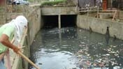
MANILA, Sept.5, 2013 - ‘Lesson not learned,’ wrote Candy Dizon in her blog, at the height of typhoon Maring (international name: Trami) in August 2013.  The businesswoman lamented how the combination of bad urban planning and uncollected trash caused the flooding in many parts of Metro Manila and halted progress from monsoon rains enhanced by the typhoon. 

Stranded and trapped inside homes for four days as heavy rains battered the metro, citizens deplored the severe flooding which paralyzed the capital Manila and inundated the surrounding provinces of Bulacan, Rizal and Pampanga. Filipinos filled social media sites with images of submerged cars on major highways, shared videos of people and parts of shacks being swept away by rampaging flood waters on a swollen river.

Days later when the typhoon had passed, a resident of Marikina city posted exasperatedly on Facebook how “flood waters on the major thoroughfares outside our residential area still have not subsided.” 

Joop Stoutjesdijk, Lead Irrigation Engineer at the World Bank, observes that at present the city just cannot cope with flooding from events like Maring, and that urban flooding is an increasing challenge to development.  Manila lies in the catch basin between Laguna Lake in the southeast and Manila Bay in the north.  Indiscriminate commercial and residential developments have blocked the path of many rivers in Metro Manila, home to some 12 million individuals and still growing.

The state weather bureau said Trami dumped more than a month’s worth of rain (almost 24 inches ) in just 24 hours in the Manila Bay area.  It has to be noted that such events would cause flooding in even the best prepared cities.

Leading the development of a 25-year Metro Manila Flood Management Master plan, Stoutjesdijk said that while the Bank has engaged in flood management for a long time in many cities around the world, the plan is one of the first ones that has looked at flood management in a very integrated manner. 

The development of the master plan was funded by a US1.5 million grant from the World Bank-administered Global Facility for Disaster Reduction and Recovery (GFDRR) Trust Fund. The grant was provided by the GFDRR using funds earmarked for the Philippines by the Government of Australia through the Australian Agency for International Development (AusAID). GFDRR is a partnership of 32 countries and 6 international organizations committed to help developing countries reduce their vulnerability to natural hazards and adapt to climate change.


" Other projects just look at a dam or some improvements in river systems. In this case, it’s a very comprehensive master plan that contains the building blocks needed for long-term development "

Joop Stoutjesdijk

Lead Irrigation Engineer, World Bank

Stoutjesdijk recalled how the development of a plan was first proposed by the Philippine government after the country was devastated by typhoons Ketsana and Parma in 2009.

Approved by the government in September of 2012, the plan consists of a number of structural and non-structural measures, including a dam in the upper catchment of Marikina city and improvements in the river systems, in particular the Pasig-Marikina river.  The plan also proposes the raising the flood plain along Laguna Lake, located south of Manila, to ensure the safety of some 300,000 people who are affected by regular flooding in the area. 

Stoutjesdijk says that while the construction of the dam and related activities such as reforestation of the upper catchment area will take a long time, small interventions are already being implemented by the government using its own funds.

 “They’ve started the dredging of water ways and modernizing pumping stations, and the Bank is helping with technical assistance to make sure that the pumps being used are modern ones and best suited for the conditions here in Metro Manila,”explains Stoutjesdijk

Stoutjesdijk says that drainage is also affected by the issue of solid waste found in waterways.“ One bottle thrown into the river or stream affects the drainage or the pumping stations, because it can cause damage to it.”

At the height of the typhoon, social media also paved the way for acts of altruism, as groups scrambled to organize relief efforts for those displaced by the massive flooding.  According to Stoutjesdijk, increasing awareness about these concepts and the need for better solid waste management is as important as the structural parts of the flood masterplan.  The response to flooding has improved a lot already since Ketsana and Parma.  “Flooding is getting well-known now among the population because it’s an annual occurrence and people are really tired of it,” observes Stoutjesdijk.

While the plan will first target Metro Manila and Laguna, Stoutjesdijk bared that the Bank has also been tasked to develop a flood master plan for the neighboring provinces of Bulacan and Pampanga in the northwest of Manila. “They have serious flooding every year, and we are looking at solutions not so much on infrastructure, but on concepts like giving room to the river, “ Stoutjesdijk says.


Api
Api

Welcome