The technology that enables us to receive signals from space has advanced by leaps and bounds since the launch of the first satellite, Sputnik, just a few decades ago.
Today, in addition to photographing the Earth or a comet, monitoring activities from above (“spying” to some) and suggesting the best route to the office, satellites are becoming allies for development.
The European Space Agency, for example, is providing data and images to international development organizations, which use them to design and implement projects in Latin America and other regions.
“The satellite observation of the Earth provides accurate information and can be used all over the world, but it is particularly useful in environments with little information, which is often the case in developing countries,” says Anna Burzykowska, a project specialist at the World Bank.
In Latin America, the information transmitted by satellites is used to prevent disasters, measure water pollution and monitor sea levels. The idea is to contribute to improving the environment for human beings and to help countries make more effective development plans.
Below are some examples of the new space odyssey: fighting poverty.
The lower water levels of Lake Titicaca in Peru and Bolivia
The Lake Titicaca Basin sits at over 3,500 meters above sea level on the Peruvian-Bolivian border. This area has a population of some three million, according to the United Nations Environment Programme (UNEP).
This landscape is threatened by pollution caused by pesticides, garbage from urban areas and waste from mining operations. Managing and regulating these different sources of contamination require data.
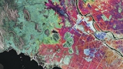
Thanks to satellite imagery, the changes in land usage and the reduced water level of Lake Titicaca were visible for the first time. These changes have devastating effects on local biodiversity.
Advanced sensors were used to measure water quality; in other words, the presence of suspended matter, chlorophyll or phytoplankton. More importantly, the sensors revealed where contamination was concentrated.
“In the case of Lake Titicaca, initial causal links were made between the sources of contamination detected and discharges from inactive mining deposits in the upper basin,” said Burzykowska.
According to the expert, this information can be correlated with on-site water quality stations to examine pollution trends and design appropriate measures to avoid more serious problems for the lake, its biodiversity and especially for the three million inhabitants living in the area.
Monitoring the health of Central American coral reefs
The Mesoamerican Barrier Reef, the second-longest in the world, is located in front of the coasts of Belize, Honduras, Guatemala and Mexico. From space, satellites have been able to monitor the state of the coral reef and some risk factors, such as water temperature or wave patterns.
It was also possible to detect where temperatures were highest. High temperatures can cause discoloration of the coral and affect the flora and fauna inhabiting the reef.
The deterioration of the reefs also means less income for people that depend on the good health of the reef, such as those involved in small-scale fishing and tourism.
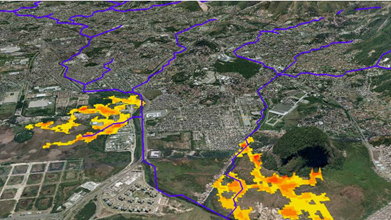
Preventing flooding and landslides in Rio de Janeiro
In 2011, more than 1,000 people died in the floods and landslides that struck the state of Rio de Janeiro. The rebuilding of roads and other infrastructure cost US$ 373 million, according to some studies.
To identify ways to avoid such high human and material losses in the future, satellite imagery was used to generate four different scenarios of the same flood event in areas with different land cover status.
These demonstrated that flooding propagates more quickly in densely-populated urban areas and that introducing vegetation in the lower watersheds can delay flooding by two hours. In watersheds fully covered by vegetation, peak water flow can be delayed for up to six hours.
“This type of information is crucial for developing disaster-prevention strategies and enabling authorities to make informed decisions on adding green and recreational areas and where the most vulnerable assets are located,” according to the report “Earth Observation for Sustainable Development.”
Additionally a detailed map of Rio de Janeiro settlements was made and those areas at highest risk for landslides were identified.
“The use of this type of information in Latin America and the Caribbean is very promising. The countries of the region have a well-developed potential to absorb technologies with the participation of their institutions and specialist technology centers, whereas government agencies have a solid capacity to apply the information for decision-making,” said Burzykowska.
The World Bank and the European Space Agency are also working together to support watershed-management projects in Mexico and forest-management projects in Chile and Argentina, as well as to assess long-term urbanization trends in Lima, Quito and Bogota.