In Ukraine: Making Land Ownership Accessible to All

March 26, 2014


When the time came to privatize her two plots of land Zhanna Kolesnik hesitated. Kolesnik is the mother of five children ranging in age from 12 to 20, and she was spooked by widespread fears in Ukraine about corruption. She was also put off by what she assumed would be a long process to register her land. But eventually she went to her local registration office, and found her fears were ungrounded.

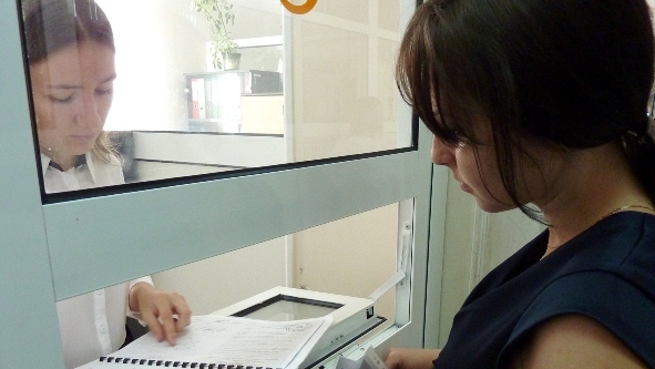
“I received two land plots from our local council – one for gardening, another for construction. I spent really little time registering these. I was able to finish all paperwork in just two visits [to the local land registration center],” she says.

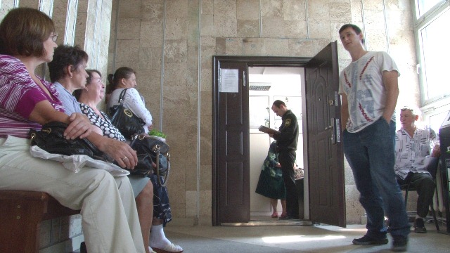
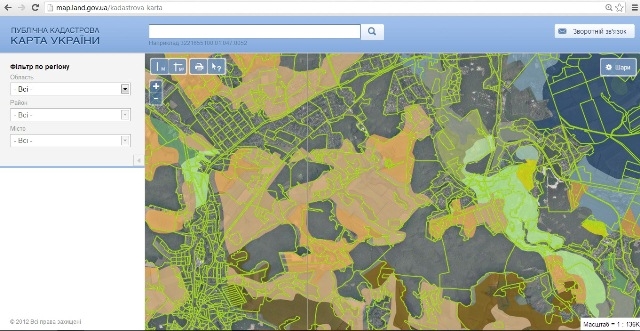
Ukraine has vast land resources. Millions of Ukrainians own land plots, as part of the government-supported nationwide privatization program that started in late 1990s. While significant governance challenges remain in the sector, as Zhanna Kolesnik’s experience shows, citizens now have better protection of their land ownership through registration in the national cadastre. Ukrainian officials also want to promote more public confidence to invest in land, and the new registration system allows land owners to engage in land transactions with full legal protection. 


" I received two land plots from our local council and spent really little time registering these. "

Zhanna Kolesnik


Image

Under the new electronic cadastral system, the registration process is faster, cheaper and more efficient; nowadays, it takes about an hour to register a land plot.

World Bank

First, Map the Land

For over twenty years of land reform and until recently, Ukraine was one of the few countries in the region without an electronic national land cadastral system, which is a complete inventory list of all registered land plots. All this has changed, with the World Bank’s help. The Rural Land Titling and Cadastre Development Project, implemented by the State Agency for Land Resources with the help of a US$89.7 million loan, has helped establish a foundation for transparent land management in Ukraine.

Up till now, it took over a month to register a land plot in Ukraine. And registration required a landowner to collect a lengthy list of up to ten documents. Now though, the State Agency for Land Resources has made the registration process faster, cheaper and more efficient.

Under the new system, and with the help of a computerized system, it takes about an hour to register a land plot.

A new, electronic land inventory and maps, along with better recording procedures have helped to slash registration time. “We’ve seen major changes and progress: we have better and faster services to citizens, and it takes less time to get the needed papers. For instance, if applicants collect all the correct documents, they can get a State Land Cadastre Certificate, confirming their land plot ownership, in just 15 minutes,” says Yuliya Synenko, a state registrar working at the Land Registration Center in Obukhiv, near the country’s capital Kiev.


" Now we have better and faster services to citizens, and it takes less time to get the needed papers.  "

Yuliya Synenko

State registrar

Image

This land registration center in Obukhiv, near Kyiv, gets over 30,000 visitors a year. A cadastral system is a complete inventory list of all registered land plots.  It is a building block for private ownership, tax payments, mortgages and investment.

World Bank

Second, Make the System Transparent

For the first time in Ukraine, all information about the country’s registered land is available to the public through a cadastral map. These maps are key elements in the new national system.  Now Ukraine’s cadastral map information is viewable on-line. Users can also search out and rectify mistakes in the existing information.  As well as reducing the registration time, this means that the owners of land plots can now receive more accurate answers to inquiries about their land’s location and characteristics, which in turn will help prevent and resolve overlapping claims.

Over 18 million state land deeds, along with administrative and topographical maps, were digitized into the new cadastral system. This amounts to over 36 million pages of information. The new land cadastre is open, transparent, automated and highly technological. It is not simply an inventory of registered land parcels, but it is, first of all, a tremendous and technologically advanced mechanism - as the experts of the State Agency for Land Resources say - which is quite unique, and which will be developed even further.

And interest is high. During the first nine months under the new system, over 800,000 new land parcels have been registered, while over 2.5 million users looked up public cadastral map information on the web.


" Today, our national cadastral system is one of the best in Europe – all this became possible thanks to our international cooperation with the World Bank experts. "

Vyacheslav Bezruk

Chairman, Obukhiv Land Resources Agency in Kyiv Region

Image

The government did much of the mapping from the air, using aerial photographs to record 60 million hectares of Ukraine’s land. Over 18 million land deeds, as well as administrative and topographical maps, were digitized into the new cadastral system. 

World Bank

Third, Fight Corruption

 Ukraine hopes the new system makes it difficult, if not impossible, to tamper with the boundaries of land plots or to burn land records, as has happened in the past. Land management has become a more transparent business altogether, as all changes to the map are submitted automatically.

The World Bank provided US$89.7 million to create the cadastral system, while about US$24 million has been used to complete aerial filming of 60 million hectares of Ukraine’s land, the first operation of its kind in the country’s history. Ukraine was one of the few countries in the region without a national land map; now it is among 50 countries in the world that does.

And, because the new system makes it easier, faster and cheaper to get information, Ukraine hopes it will promote land sales and investment in rural areas, and that it will encourage new loans, mortgages and economic growth for millions of Ukrainians.

Image
18 million
state land deeds, along with administrative and topographical maps, were digitized into the new cadastral system. This amounts to over 36 million pages of information.
Source »

More Results


Welcome