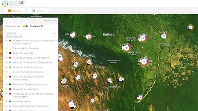
Indigenous communities, municipalities, departments, the press, the general public – everyone will be able to access information on 31,000 public investment projects via the Internet and in real time.
In this initial phase, technical teams of the Ministry of Planning, the World Bank Institute and the Catholic and San Simón de Cochbamaba universities have geo-referenced 4,700 projects financed by 30 international cooperation agencies.
After two years of work, and based on the Open Aid Partnership implemented by the World Bank, Bolivia is the first Latin American country to generate a map that reflects its specific development needs.
“To have information available and monitor it means that even the most remote municipality can access and use this platform. This information is for mayors, neighborhood associations and farmers’ organizations. They are the ones who want to see how their projects are advancing” said Development Planning Minister Viviana Caro. “The country and especially our beneficiaries want to know whether the projects are registered; the level of budget execution; and the possibility of developing other applications for disaggregating [information]."
The “Public Investment Map of Bolivia” was implemented to disseminate information, but also to collect it, for which reason over 450 entities at the central, departmental and municipal levels are required to register their investment projects in this system.
“This is an evolving process. Currently we have concise data which we will be adding to; later we will show more: budgets, spending levels and other disaggregated information,” said the Vice-minister of Public Investment, Harley Rodriguez. “Basically it will be a territorial and sectoral planning tool based on needs and national public policies; however, it will also be a mechanism for transparency and social oversight,” he added.
With the adoption of the Telecommunications Law, which allows for the use of free software tools, sub-national governments hope to improve their information with their own mapping in an effort to complement rather than duplicate efforts.
“For us, the Open Aid Map helps partners in Bolivia to improve the approach, monitoring and evaluation of their activities and thus to be able to better tailor them to the country’s development priorities and plans,” said the World Bank Resident Representative in Bolivia, Faris Hadad-Zervos. “This joint effort shows us that we have learned from each other and we now have a better tool.”
The World Bank will continue to work closely with the country on this initiative, enabling programs adapted to each country to become a south-south cooperation experience. The next step could be to include photos of public investment projects and those funded by outside financing on the platform, with a view to demonstrating advances; for example, photos of the construction of a highway.
Honduras will be the second Latin American country to implement the Open Aid Map. The first pilot countries for this initiative were Bolivia, Kenya, Malawi and Nepal. Sierra Leone and Afghanistan have now joined this group.
The World Bank launched the Open Aid Partnership, an initiative created to improve transparency in development aid and government budgets, in 2011.

