FEATURE STORY

Philippines: Geo-tagging for Efficient, Cost-Effective Project Management

February 19, 2013


Image

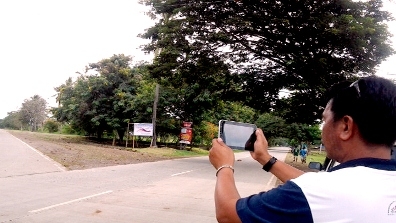
An employee from the Department of Agriculture takes a photo of a road project in the Philippines as part of geo-tagging activities for the Second Mindanao Rural Development Program (MRDP2). The government agency pioneered the use of the technology in managing the Bank-assisted program, that's now being replicated in other agencies and in local governments. (Watch slideshow

Photo: Department of Agriculture

STORY HIGHLIGHTS
  • Spread over 6 regions, the Second Mindanao Rural Development Program faces challenges of accessibility, manpower, resources and security concerns.
  • Geo-tagging technology allows projects in remote and conflict-affected locations to be easily and accurately located, managed and validated.
  • The program makes innovative use of geo-tagging for improved transparency and effectiveness in procurement and project management.

If you’re into web-based maps like Google’s to track your travels across the globe, or if you’ve participated in a crowd-sourcing project to report a bribe, then you’re already familiar with uploading photos and other information that’s location-specific. What you probably don’t know is that this tool can also be used for monitoring government projects in far-flung places.

Employees from the Department of Agriculture (DA) and local governments in the Philippines didn’t know either. “This too shall pass,” was the general comment and frame of mind of most employees recalls engineer Arnel de Mesa, when he first broached the idea of using geo-tagging in 2010 to monitor a World Bank-assisted project.

De Mesa is the deputy program director for the Second Mindanao Rural Development Program or MRDP2 being implemented by the DA. Through the involvement of local governments and rural communities, the project has been able to raise the average household income of beneficiaries by 16% from 2007 to 2011.

Nowadays, de Mesa’s team is leading efforts to train their co-workers within the agency and outside the department on the use of geo-tagging for project management. Their innovative use of the technology is the first among government agencies in the Philippines, and among the pioneers in the region.

De Mesa and his team had been experimenting with a variety of complex systems that would allow them to effectively supervise, validate and evaluate about 500 rural infrastructure subprojects – from identification, procurement, implementation, and up to the evaluation phase. De Mesa and his Mindanao-based team finally found the answer in geo-tagging technology, which he said government workers assigned to the program later warmed up to.

The geo-tagging process involves attaching location-specific information such as geographical coordinates to pictures, videos and even SMS messages. Users would need a GPS-enabled phone and internet connection to upload multimedia to a web-based application such as Google, which provides the platform to geo-tag at no cost.


" The beauty of geo-tagging is that one does not have to be an engineer to learn it. Anyone can learn the ropes "

Arnel de Mesa

Engineer and Deputy Program Director for the Second Mindanao Rural Development Program

Today, members of his team and participating local governments in Mindanao, armed with GPS-enabled cameras and tablets, document their various project sites to take before, during and after photos of project implementation that include bridges, farm-to-market roads, irrigation systems, livelihood and even marine sanctuaries with a special underwater camera.  Reluctant before to use the technology, the team is now counting its many benefits:

• Cost-efficient and safe –the technology enables the project team to validate, monitor and evaluate actual progress on the ground without having to travel to hard-to-access locations and areas with high security risk, saving them precious manpower resources, time and effort.

• Easy reference - the technology provides donors, implementing agencies, contractors and other partners  with useful information about its sub-projects such as exact locations, dates of operation, land areas, distance covered and where they are situated in relation to other landmarks in the area (see www.damrdp.net)

• Transparent - other information, such as invitations to bid for projects, is also available on the maps for the benefit of prospective bidders. At the same time, it allows citizens to better monitor the bidding and procurement process.  The GPS data compiled in the system assigns a unique identification tag for each project , avoiding duplication and overlapping of infrastructure projects, thus eliminating fictitious projects, as well as false reporting of data.

Award-Winning Program

When Mindanao Rural Development Program Phase 2 was recently hailed by the Philippine National Economic and Development Authority for applying geo-tagging technology in “resolving recurrent issues in project implementation,” De Mesa was ecstatic. “We really wanted to show that we’re doing something for good governance and transparency,” he explained.

For De Mesa, the ‘Good Practice Award’ granted to the program reinforces the Aquino administration’s efforts to curb corruption and improve governance. While it marked the first time that the technology had been used by a government agency to promote transparency in a development project, it was not going to be the last.

The Department of Agriculture is already looking forward to use geo-tagging to build up its database in order to strengthen agricultural and fisheries development planning.


(For more information please see the project detail page or the Department of Agriculture website. You may also email Carolina V. Figueroa-Geron, World Bank Lead Operations Officer, EASPS at cfigueroageron@worldbank.org or Engineer Arnel de Mesa at demesaarnelvillegas@yahoo.com.)


Api
Api

Welcome